
“Mortimer, how long is a Degree of Latitude?”
Mortimer S., with arms out-stretched: “About this long. Who wants to know? “
Carl S: “Scientists, geographers, and surveyors want to know the size and shape of the Earth.”
Mortimer: “Shape? I thought it was flat.”
Carl: “No, it’s an oblate spheroid.”
Mortimer: “I’m glad you cleared that up for me. OK, I’ll bite, how long is a degree of latitude?”
Carl: “That depends.”
Mortimer: “Depends on what?”
Carl: “Where you measure it.”
Mortimer: “Gosh”! [Pauses, anxious to change the subject.] “Do you want a root beer?”
******************************
It is not a difficult stretch to suggest that long ago early seafarers and coastal residents recognized that the Earth was not flat when they saw ships disappearing beyond the horizon yet later returning. While a few scientists knew the earth was a sphere before the Common Era, by the year 1000 most intellectuals, scientists and seafarers knew the earth was a sphere. Of course, Columbus knew the earth was a sphere. His problem was, that in order to sell his idea, he accepted the circumference used by Martin Behaim in his famous contemporary globe – 18,000 miles. The first direct demonstration of Earth’s sphericity (the word for the day) was the first circumnavigation of the world in history – the expedition lead by the explorer Ferdinand Magellan in 1519-1521.
A remarkably precise measurement of the earth’s circumference was made by the Greek mathematician Eratosthenes about 230 BCE. He knew that at noon on the first day of summer the sun shone directly into a well at Syene (now Aswan), Egypt. He found that at the same time in Alexandria, 5000 stadia due north of Syene, the sun stood at 7.2 degrees from the vertical. With these measurements he could compute the length of one degree (5000 stadia or 489 miles divided by 7.2°) or 67.92 miles per degree of latitude. Therefore, the earth’s circumference must be 360 ° x 67.92 miles per degree or 24,450 miles. Note: The actual length of one stadia used by Eratosthenes is uncertain. These calculations assume he used “Egyptian stadion” of about 157.5 meters.
Around 830, a group of Muslim astronomers and geographers measured the distance between two cities in modern Syria. Using measurements to the sun, they found the cities were separated by one degree of latitude. They knew the distance between them was 66 2⁄3 miles. They calculated the Earth’s circumference to be 24,000 miles (360 degrees times 66 2/3 miles per degree = 24,000 miles).
Later, more precise measurements in various areas of the world arrived at different lengths for one degree of latitude. What did this mean? It meant the Earth is not a perfect sphere.
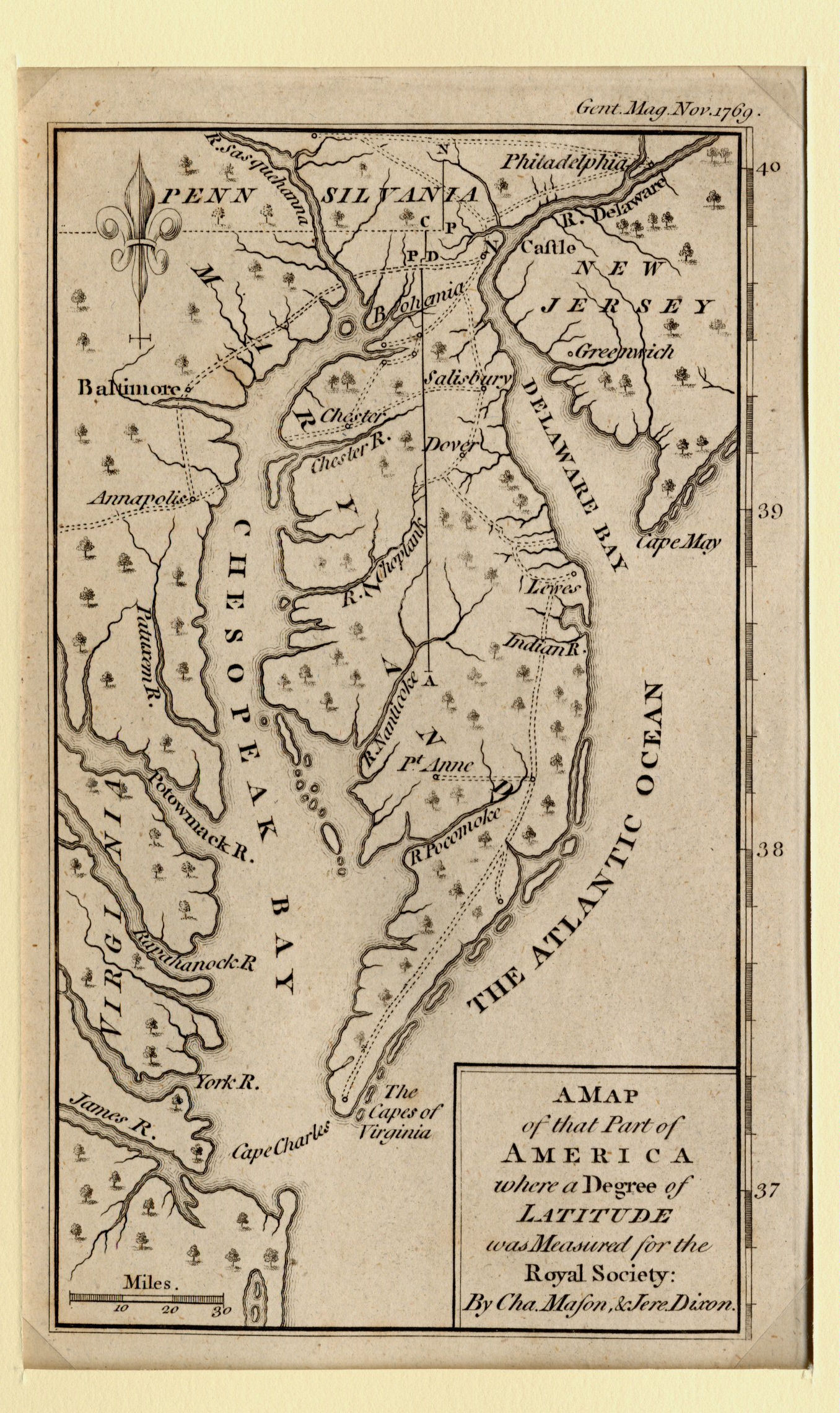
A Map of that Part of America
where a Degree of Latitude was Measured
The origin of this map about a degree of latitude lies in the boundary dispute between Maryland and Pennsylvania. The original land grants for Maryland gave Lord Calvert the land to 40° north latitude and for Pennsylvania gave William Penn the land north of the 40th parallel. It soon became obvious that Philadelphia had been founded on land south of the 40th parallel, and, thus, was situated in Maryland. The issue was not resolved until the British Crown intervened in 1760, ordering the Calverts to honor an earlier agreement with the Penns wherein the boundary line between Maryland and Pennsylvania would be relocated south of Philadelphia.
Charles Mason and Jeremiah Dixon made the surveys of this new boundary and the other common boundaries of Pennsylvania, Maryland, Delaware and Virginia during the period 1763-1768. While there, they also measured the length of a degree of latitude on the Delmarva Peninsula for the Royal Society. They spent about four months in early 1768 working on the latitude measurement project, using high-precision measuring levels with adjustments for temperature. Mason’s final calculation, published in the Philosophical Transactions of the Royal Society in 1768, indicated a degree of latitude on the Delmarva Peninsula from the middle point northward covered 68.7291 miles.
Modern measurements indicate the circumference of the earth through the North and South Poles is 24,859.82 miles with the length of one degree of latitude varying from 68.707 miles at the Equator to 69.054 miles at latitude 45° north to 69.403 miles at the North Pole. The circumference at the equator is 24,901.55 miles (69.1706 miles per degree of longitude), 41.73 miles greater than the Polar diameter. Therefore, the earth is oblate; that is, shaped like a flattened sphere with the diameter at the equator greater than the diameter through the poles, all because two major forces of nature are in an eternal struggle – one says make the earth a perfect sphere; the other says no, I am stronger.
Carl: “See, Mortimer, the length of a degree of latitude does depend on where you measure it.”
Quiz:
(1) What two forces are involved in making the earth an oblate spheroid?
(2) Who was Mortimer S in the conversation above? I’ll give you a hint. He was a protégée of ventriloquist Edger Bergen.
(3) Who was Carl S? Hint – He once had a TV program called “cosmos”
Tales from the Rare Map Cabinet by Luke A Vavra
Stock Number N6178 MAP SOLD