
RICHMOND, VIRGINIA AND THE AMERICAN CIVIL WAR
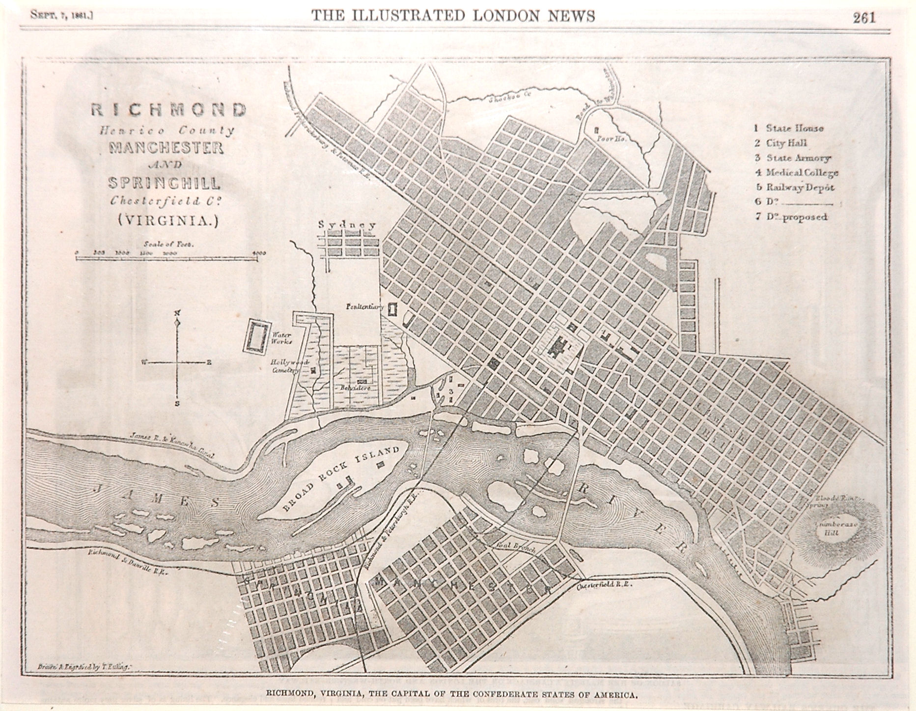
MAP TITLE: Richmond Henrico County Manchester and Springhill Chesterfield Co. (Virginia.).
Published in The Illustrated London News. 1861.
This September 1861 London newspaper plan of Richmond, Virginia depicts the city just after the opening of the American Civil War. Richmond had been founded at the fall line of the James River in 1737. In 1780 it became the capital of Virginia, replacing Williamsburg and the first capital, Jamestown. Its capitol, identified as “State House”, is shown on this plan.
The anti-slavery stance developing in the Northern states led seven Southern states to secede from the Union in February 1861 and form the Confederate States of America. But the Civil War did not begin until April 12, 1861, when Fort Sumter, located at the entrance to Charleston Harbor in South Carolina, was bombarded after refusing to surrender to the Confederate forces. Virginia and other states then seceded and joined the Confederacy. Montgomery Alabama had been chosen as the new capital of the Confederacy, but the capital was relocated to Richmond on May 21, 1861.
At that time, Richmond’s population was the South’s largest and her industrial capacity nearly equaled the other Confederate states combined. The Tredegar Iron Works located along the James River was the only plant in the South capable of manufacturing heavy weapons, munitions and locomotives. On the negative side of that decision to focus on Richmond was the risk posed by Richmond’s proximity and accessibility to Union forces; Washington, DC was only a hundred miles away.
At the conclusion of the war in 1865, Richmond suffered greatly – Confederate forces were under orders to set fire to bridges, the armory and warehouses as the forces abandoned the city. The fires spread out of control and large parts of the city were destroyed. Luckily, the capitol building, shown on this plan, was spared .But, there was good news for map collectors! Confederate General Jeremy Francis Gilmer managed to leave with about 60 Confederate maps of Virginia counties. These were later acquired by the Virginia Historical Society and reproduced A complete set is available on our site.
ABOUT THE MAP (sold earlier):
Published in The Illustrated London News. 1861.
TITLE: Richmond Henrico County Manchester and Springhill Chesterfield Co. (Virginia.).
Size: 6.7″h x 9.4″w. Upper left: Sept. 7, 1861. At the lower left: Drawn and Engraved by T. Ettling. Below the neatline: Richmond, Virginia, the Capital of the Confederate States of America.
Published in the September 7, 1861 edition of The Illustrated London News. Theodore Ettling (b. 1823) was an engraver, lithographer and draftsman in Amsterdam before moving to London. He engraved several maps of the Civil War areas for The Illustrated London News.
Hollywood Cemetery is on the outskirts of town. In town the State House, City Hall, State Armory and Medical College are identified on the city plan. The James River & Kanawha Canal leads into the City from the west.
The English were eager to learn about this civil war in their former colonies, and this is one of the earliest newspaper maps to depict Richmond.
Tales from the Rare Map Cabinet by Luke A. Vavra
N3115
Leave a Reply