
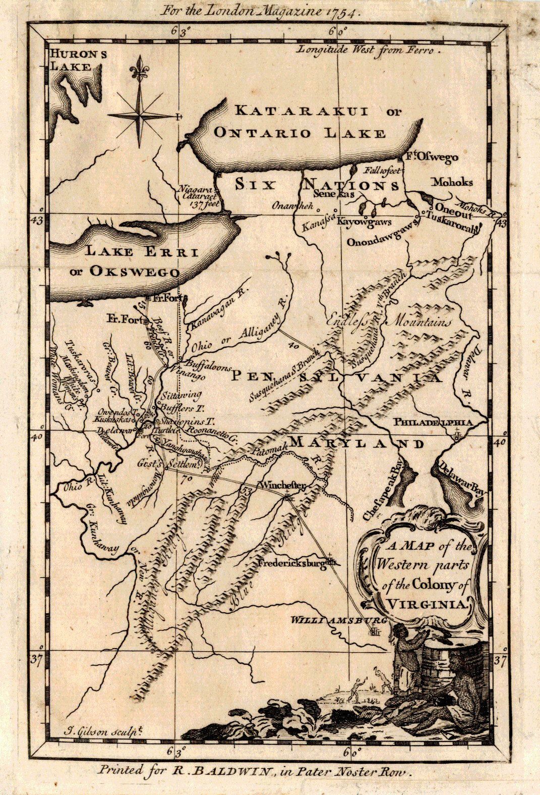
A Map of the Western parts of the Colony of Virginia.
In late October, 1753, twenty-one year-old Major George Washington was ordered by Robert Dinwiddie, Lieutenant-Governor of the Colony of Virginia, to take a letter from Dinwiddie to the commander of French forces in the Ohio Country. That letter unabashedly requested the “peaceful departure” of the French from the lands along the Ohio River. The Frenchman La Salle had explored the Great Lakes Region and the Mississippi Valley during the period 1667-84. He claimed the entire region watered by the Mississippi River and all its tributaries for King Louis XIV of France, naming the region “Louisiana.”
You will recall that the Ohio is a major tributary of the Mississippi. Britain claimed the area of a large Virginia including Ohio, stretching from “sea to sea” based on a 1609 charter. Up to this time neither side had used military power to enforce its claim. Fur traders from both England and France arrived in the Ohio Country beginning in the 1740s. By the 1750s, English colonists, especially the investors in the Ohio Company (such as Dinwiddie), were anxious to expand into that area. Each side attempted to deny the other access to the Ohio Country. The French military occupied the Ohio Country and began to build forts. This was the scene Washington was about to enter.
Washington set out immediately from the Virginia capital, Williamsburg, proceeding to Fredericksburg where he picked up a French interpreter, and on to Alexandria, Winchester, “Gist’s Settlement” on the Monongahela River, Venango on the Allegheny River, and finally to the French Fort Le Boeuf near Lake Erie. It was an arduous journey, mostly in the dead of winter, ending back in Williamsburg in mid-January, 1754.
Washington presented the letter to the French commander during a dignified, diplomatic meeting. Both were well aware of the tensions between England and France, and neither wanted to create an incident. The commander gave Washington a cordial, diplomatic letter to Dinwiddie saying in French, “As to the Summons you sent me to retire, I do not think myself obliged to obey it.” Upon his return Washington prepared a written report of his trip which was published in only a few copies making it one of the rarest publications in Colonial American history.
The British public was hungry for news of the impending conflict, and in June, 1754 the London Magazine published A Map of the Western parts of the Colony of Virginia to accompany an excerpt from George Washington’s journal. Washington’s route to Fort Le Boeuf is shown on this map. Note, with this map the London Magazine graphically asserted that the disputed land was part of Virginia.
Washington was to return to the Ohio Country a few months later, this time with approximately 400 Virginia militiamen, to drive the French from the region. In May 1754, they ambushed a French patrol. In retaliation, the French captured Washington and his men at Fort Necessity in July, but released them to return to Virginia. The American phase of the Seven Years War had begun; we know it as the French and Indian War. Washington had twenty more years to reflect on his loss in battle on behalf of Britain before being called to lead the victorious Continental Army against Her.
Tales from the Rare Map Cabinet by Luke A. Vavra
Stock Number RV016 MAP HAS BEEN SOLD
Leave a Reply