
Author: ute239
-
DOES EDITION REALLY MATTER?
BOOKS: If you collect books, you already know the answer. First editions of books are, almost universally, much more valuable than later editions – occasionally reaching tens of thousand dollars higher for “best sellers”. A first edition a book is considered more valuable simply due the significance of s being the very first appearance of…
-
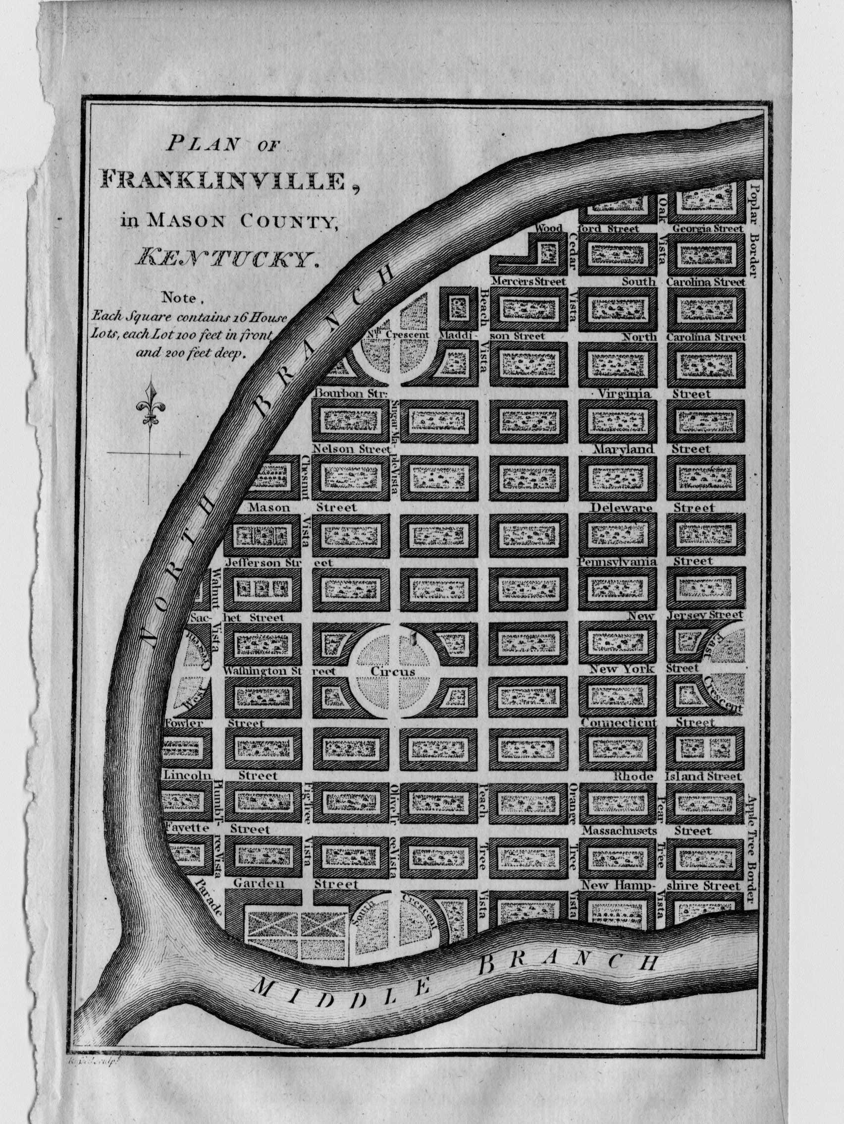
TWO KENTUCKY TOWNS THAT NEVER WERE
Plan of Lystra, in Nelson County, Kentucky. Plan of Franklinville, in Mason County, Kentucky. Two towns, Lystra and Franklinville, Kentucky were separately mapped and appear on at least one antique map of Kentucky. Where are they now? Plans for these two towns by John Russell are found in William Winterbotham’s four-volume history of North America…
-

MERCATOR PROJECTION, RHUMB LINES AND MERIDIANS
The above sketch depicts a great circle and one possible rhumb line connecting two distant locations. Although I am a graduate Civil Engineer and should remember all of the following narrative, I admit I referred to Wikipedia several times. Most of us who look at antique maps have seen lines radiating in many directions from…
-

The “Dog Days of Summer” – A Map of the Night Sky.
Figuras Tabula Uranoscopica, Exhibens Orbitas Duorum Istorum Insignium Cometarium … 1665 Did you ever lie on the grass at night, look at the stars and wonder what’s up there? So did the ancient people. But they saw animals, fish, ships, people and much more. They saw “constellations” – groups of the brighter stars that form…
-

Collecting Antique Maps
Much has been written about collecting rare and antique maps, and countless talks and seminars have been given about the subject. What more can I add? I think I should keep this brief and focus on one thing- you! Why are you even reading about collecting? Somehow, you found your way to my internet site…
-
WHERE IN THE WORLD IS THE “PRIME MERIDIAN”?
Prime Meridians are north-south zero lines from which longitude is measured. Longitude is usually measured up to 180 degrees east and west of the prime meridian although some early maps show longitude up to 360 degrees east or west of the prime meridian. It was not until 1884 that the Greenwich, England meridian was adopted…
-

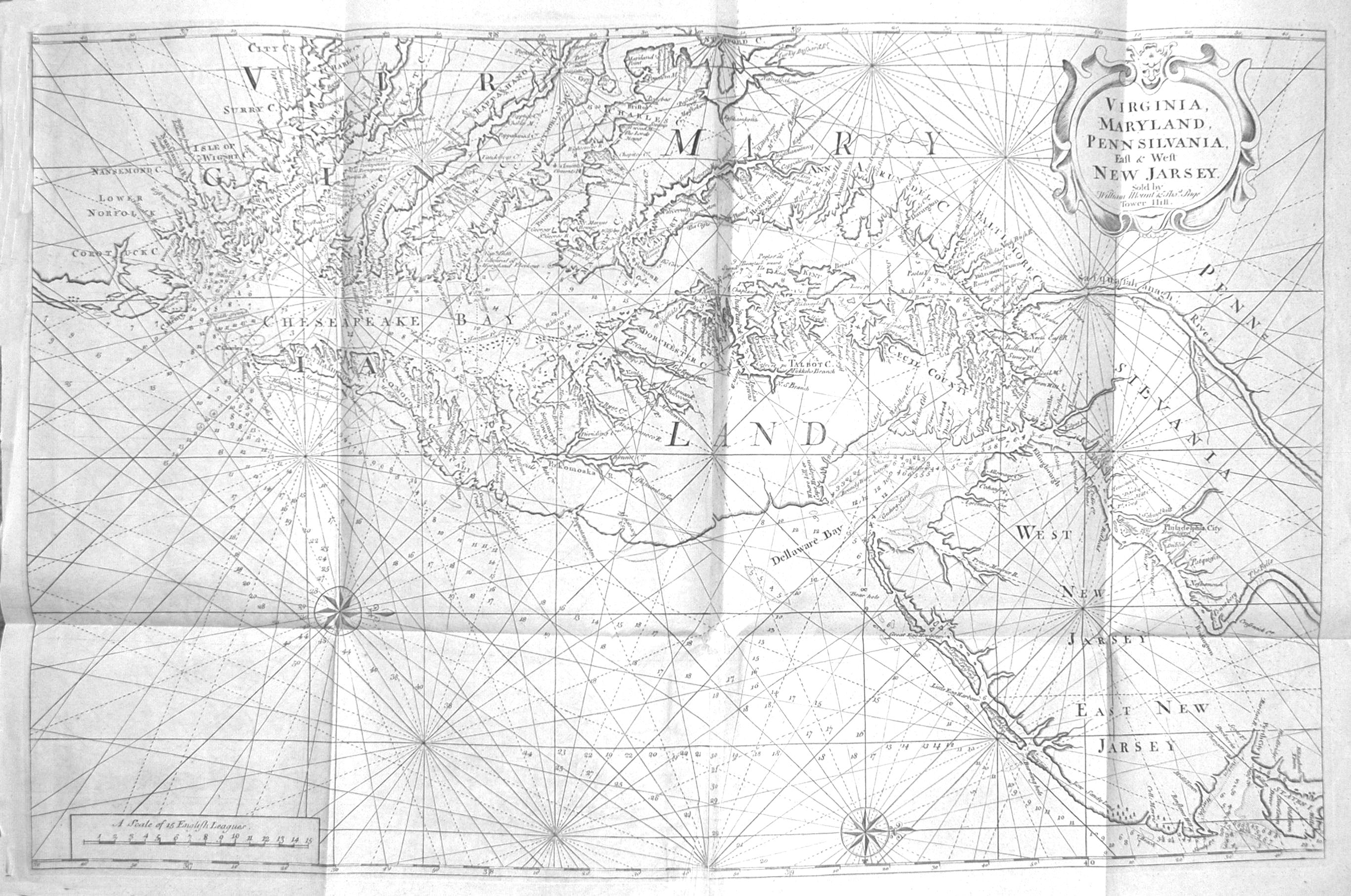
VIRGINIA. LONDON MAGAZINE. WASHINGTON’S JOURNEY. 1754.
A Map of the Western parts of the Colony of Virginia. Top margin: For the London Magazine 1754. Lower margin: Printed for R. Baldwin, in Pater Noster Row. Lower left: J. Gibson Sculp’t. Published in London by R. Baldwin, 1754. This map covers the region from Lakes Erie and Ontario south to New River and…
-

Lord Dunmore’s Depredations
Map of the Maritime Parts of Virginia Exhibiting the Seat of War and of Ld. Dunmore’s depredations in that Colony. This map appeared in the April 1776 issue of The Pennsylvania Magazine, published in Philadelphia. The magazine had been founded by Robert Aitken and was edited by Thomas Paine. The map is coarse and crudely…
-

More than meets the eye on this map of the Atlantic Ocean.
The Atlantic Ocean by Governor Pownall, F.R.S. At a glance this map from the late 1700s with its diagrams of the ocean currents seems made for the shipping trade. The sea is mapped with arrows charting directions of ocean currents and winds. A shaded area indicates the “Gulf Stream or Florida Stream”, obviously copied from…
-

Decisions, Decisions: The Story Behind a Map.
Les Cotes de la Virginie, les Detroits de Frobisher et de Hudson. This small map reminded me of how much depends on decisions made over 400 years ago – decisions that had a profound impact on America. This seemingly unimportant map was printed in three versions: French, English and Dutch, resulting in a mixture of…